
Major changes to Brisbane Airport’s flight paths are expected to reduce aircraft overflights for tens of thousands of residents across South East Queensland.
On 9 July 2026, Airservices Australia announced the outcomes from Package 3 of its Noise Action Plan for Brisbane, following community and aviation-industry consultation conducted during July and August 2025.
The changes affect arrival and departure routes across a broad area – from Bribie Island and Moreton Bay to Brisbane’s eastern and southern suburbs and communities further south towards the Gold Coast.
According to Airservices Australia, the four principal changes are expected to reduce the number of residents overflown by approximately 138,500 across the affected routes. This has been widely reported as almost 140,000 residents benefiting from the overhaul.
However, the outcome will not be positive for every household. Moving a flight path away from one populated area can redirect aircraft towards another, making it important for homeowners and property buyers to examine the detailed maps rather than relying solely on suburb-level information.
What flight path changes are being introduced?
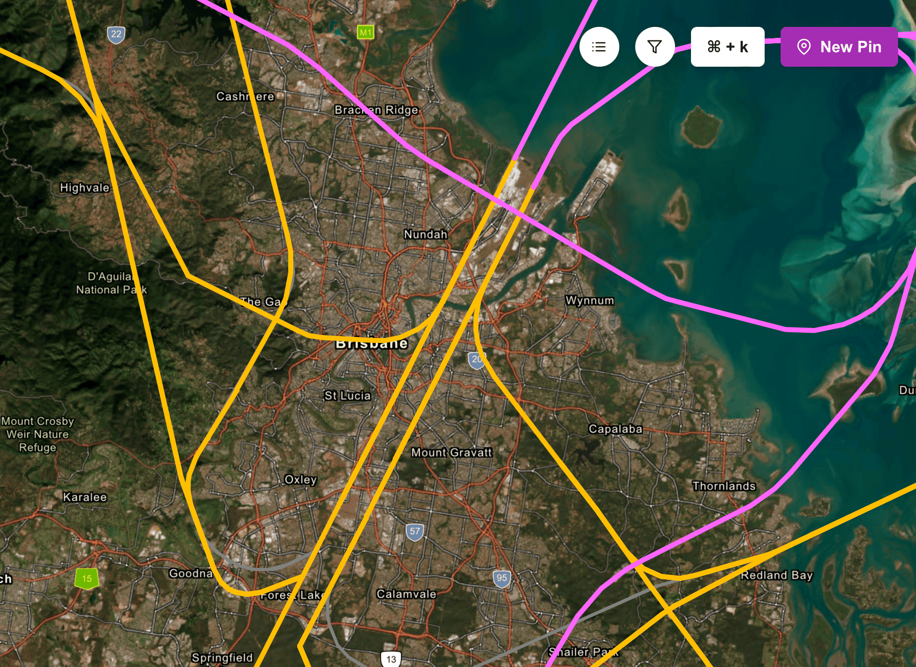
Image – Current flight paths (July 2026); wind from the north (day). Image courtesy of Air Services Australia
1. Northern arrivals over Moreton Bay will move further north
Arrival paths approaching the northern end of Brisbane Airport’s new runway over water will be shifted further north.
Airservices Australia estimates this will reduce the number of people overflown by approximately 59,000, including residents in the southern part of Bribie Island.
The intention is to keep more aircraft movements over water and reduce the number of densely populated residential areas beneath the approach route.
However, residents closer to the adjusted flight path may notice a change in the location, frequency or visibility of aircraft. The impact will vary according to the aircraft, weather, runway direction, altitude and time of day.
2. New short approaches for non-jet aircraft
New short-approach connections are also being introduced for non-jet aircraft arriving at the northern end of the new runway.
A short approach allows an aircraft to turn and line up with the runway closer to the airport rather than following the full-length arrival route.
Airservices says this will provide more opportunity to distribute aircraft noise between long and short approach paths and reduce the visual impact of arrivals over parts of Redcliffe.
These connections apply to non-jet aircraft rather than the larger passenger jets that account for many of the most noticeable aircraft movements.
3. Southern arrivals to both runways are changing
Arrival routes to the southern end of both Brisbane Airport runways are being modified.
The new routes are designed partly to accommodate Independent Parallel Runway Operations, commonly referred to as IPRO. This allows aircraft to arrive simultaneously on Brisbane Airport’s two parallel runways.
Although regular use of IPRO is not expected until late 2027, the revised southern arrival routes commenced operating on 9 July 2026, allowing some of the noise-reduction benefits to begin sooner.
Airservices Australia estimates these changes will reduce the overall population overflown by approximately 35,000 residents.
The Courier Mail reported that the affected changes extend across numerous communities between the northern Gold Coast and the Brisbane metropolitan area.
4. South-east departures will move further east
Departure routes from Brisbane Airport’s original – or ‘legacy’ – runway towards the south-east will be shifted further east.
Airservices estimates the change will reduce the population overflown by approximately 44,500 residents.
The organisation has indicated that minor adjustments may still be considered during the final design process in response to concerns raised by communities on the Southern Moreton Bay Islands.
This is an important reminder that announced routes may still be subject to detailed design, safety assessment and operational refinement.
A possible new night-time departure over the airport
Airservices Australia is also continuing safety work on a proposed night-time departure route from the new runway.
Under the proposal, aircraft would cross in front of the legacy runway before turning over Moreton Bay. The objective is to provide another route that may allow additional night-time departures to operate over water rather than residential areas.
This proposal has not yet been confirmed for trial. Further safety work must be completed before Airservices decides whether it can proceed.
Why are Brisbane’s flight paths changing?
The changes form part of the broader Noise Action Plan for Brisbane, which was developed following the opening of Brisbane Airport’s second parallel runway in July 2020.
The new runway significantly changed the way aircraft operate across Brisbane’s airspace. While it increased airport capacity and created opportunities for more flights to operate over Moreton Bay, it also resulted in new or intensified aircraft-noise impacts for some communities.
Airservices Australia says it considered a combination of factors when assessing the Package 3 options, including:
- the number of people overflown
- expected noise levels
- the frequency and cumulative impact of flights
- aircraft altitude
- additional distance travelled
- operational efficiency
- aircraft emissions
The objective is not simply to move every aircraft over water. Flight paths must also comply with safety requirements, interact effectively with other arrival and departure routes, and remain practical for different aircraft types and weather conditions.
Check how the flight path changes affect your home
Aircraft-noise impacts can vary significantly within the same suburb. A house located directly beneath a flight path may experience a very different level of aircraft activity from another property only a few streets away.
Airservices Australia has published an interactive map showing the current and proposed flight path arrangements considered under the Noise Action Plan.
Interactive Noise Action Plan map
Use the following map to explore the routes and zoom in on particular neighbourhoods:
View the Airservices Australia Noise Action Plan interactive map
The map is useful for understanding the broad alignment of the flight paths, although the lines should not be interpreted as showing the exact location of every aircraft. Actual tracks can vary because of weather conditions, air-traffic-control instructions, aircraft performance and operational requirements.
View actual aircraft movements using WebTrak.
Airservices Australia’s WebTrak system allows residents to examine actual and historical aircraft movements around Brisbane Airport.
Users can enter a street address, display their home on the map and review information including an aircraft’s route, altitude, aircraft type and closest point of approach.
Open the Airservices Australia WebTrak information page.
Aircraft in Your Neighbourhood
Airservices also provides location-specific information explaining the flight paths, runway operations and aircraft-noise patterns affecting different Brisbane communities.
Search the Aircraft in Your Neighbourhood portal.
These resources are best used together:
- Review the proposed or revised flight paths on the Noise Action Plan map.
- Enter the property address into WebTrak.
- Examine actual aircraft movements on different days and at different times.
- Review the neighbourhood information provided by Airservices.
- Visit the property when relevant flights are likely to be operating.
What do the changes mean for Brisbane property buyers?
Aircraft noise is an important – but sometimes overlooked – part of property due diligence.
It can affect a property’s enjoyment, particularly where aircraft movements occur early in the morning, late at night or repeatedly throughout the day. Outdoor living areas and bedrooms may be particularly affected.
However, being near a mapped route does not automatically mean that a property will experience unacceptable noise. The impact depends on factors such as:
- whether the property sits directly beneath or beside the normal flight track
- the altitude of aircraft in that location
- whether the route is used for arrivals or departures
- prevailing winds and runway direction
- how frequently the route is used
- the aircraft types using the route
- the property’s orientation, elevation and surrounding terrain
- the quality of insulation, windows and building construction
Aircraft generally take off and land into the wind. Consequently, the runway and flight paths in use can change according to prevailing wind conditions. A property that appears relatively quiet during one inspection may experience different activity under another weather pattern.
How to assess aircraft noise before buying
Online maps are an excellent starting point, but they should not replace an on-site assessment.
Inspect at different times.
Attend the property on more than one occasion, including during the early morning, evening and weekend periods where possible.
Spend time outside
Stand in the backyard, entertaining area and street rather than assessing noise only from inside the house.
Speak with nearby residents.
Neighbours can often provide useful information about how frequently aircraft pass overhead and whether activity changes at night or under different weather conditions.
Check actual flight history.
Use WebTrak to review movements over several representative days rather than relying on a single snapshot.
Consider the property itself.
Double glazing, insulation, building materials and the positioning of bedrooms and outdoor areas can substantially influence how aircraft noise is experienced.
Recheck the new routes.
Previous knowledge of a suburb’s aircraft-noise exposure may no longer be reliable following the July 2026 changes. Buyers should use the latest available maps and flight data.
Will the changes affect property values?
It is difficult to predict how the revised routes will affect individual property values.
Properties experiencing a meaningful reduction in regular overflights may become more appealing to some buyers. Conversely, households newly located beneath a more frequently used route may regard this as a disadvantage.
Any effect is likely to be highly localised. Aircraft activity is only one of many factors influencing property demand, alongside location, school catchments, transport, housing supply, land characteristics, property condition and broader market conditions.
For buyers, the practical issue is not to assume that a whole suburb is either ‘affected’ or ‘unaffected’. Flight path exposure should be assessed at the individual-property level.
An important change – but not the end of the process
The July 2026 announcement represents a significant stage in Brisbane’s ongoing flight path review.
Four major changes are progressing, with the combined routes expected to reduce the number of residents overflown by almost 140,000. At the same time, some aircraft movements will inevitably be redistributed to other locations, and the proposed night-time over-airport departure remains subject to further safety work.
For Brisbane homeowners and buyers, the most useful response is to examine the interactive maps, review actual flight activity and consider aircraft noise as part of a broader property due-diligence process.
Flight paths can be difficult to assess from a standard property inspection. Taking the time to investigate them before purchasing may help avoid an issue that only becomes apparent after moving into the home.